Bathy DataBASE
Future-Proof Bathymetric Data Management
Powered by the CSAR engine and backed by proven RDBMS technology, Bathy DataBASE delivers a robust and scalable solution for the storage and analysis of ever-expanding volumes of sonar and lidar data.
Bathy DataBASE easily incorporates all sources of data from historical field sheets to the latest high density multibeam surveys in a single space.
Manipulate, analyze and compile data using intuitive tools, and create bathymetric and cartographic products with confidence.
Contact Us

Core Features
Data management and storage
Backed by the proven RDBMS technology of PostgreSQL and Oracle Spatial, the Bathy DataBASE Server offers a secure and reliable mechanism for storing and managing bathymetric data.
Data analysis
Visualize data in 2D and 3D. Display data over OGC services. Use difference, profile tools to compare data.
Merge different data sources
Through the combine process, combine data from historical field sheets to the latest high density multibeam surveys in a single space.
Vector bathymetric product creation
Create contours, soundings and meta object for cartographic purposes. Use batch tools and APIs to load bathymetry datasets into the Bathy DataBASE Server as fully attributed objects.
Automation
Process model and python automate allows any workflow to be fully automated which can be launched in one click from BASE Editor.
LAS lidar support
Clean and classify lidar points in Subset Editor, S-57 vector objects creation directly from the point cloud in Subset Editor or the 3D Viewer.
Video recording
Create a fly-through video using our 3D view for any type of bathymetric data.
Feature Highlights in version 6
Teledyne Geospatial is pleased to announce the release of CARIS BASE Editor 6.1 now including enhanced automation through integrated python support to CARIS process models. Additionally, BASE Editor 6.1 adds "on-the-fly" vertical transformation providing a user-friendly way to display data in a different vertical datum.
* Note - An updated license file will be required to use BASE Editor 6.1.
SEP 25, 2023
Automation
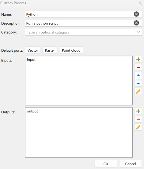
To integrate with third-party solutions or to include with individual business logic, BASE Editor can now use custom processes written in python scripts and use CARIS Process Designer to add them inside a process model. Additionally, CARIS Batch can now be used to launch process models. The combination of these functionalities enhance CARIS automation tools making it possible to execute automated workflow across CARIS applications.
These different tools provide the ability to use a single application as a hub to launch automated workflows.
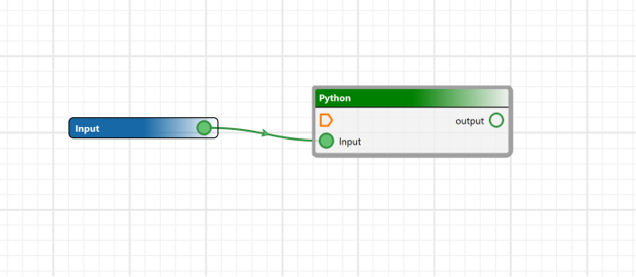
Python Support
Python scripting is the most flexible way to use CARIS Bathy DataBASE for automating workflows and support is now available for version 3.9, 3.10 and 3.11. Updating to new versions of Python helps safeguard IT infrastructure so join CARIS in upgrading today. Based on in-house testing, upgrading from Python 3.5 or 3.7 to 3.9, 3.10 or 3.11 should have minimal impact on user scripts.
On-the fly transformation
With the release of CARIS BASE Editor 6.1, new tools are available to apply vertical transformations using EPSG registered vertical datums. To provide more flexibility for customers, BASE Editor 6.1 provides the ability to create your own vertical datum using customers' own transformation models.
In addition, a new "on-the-fly" feature delivers vertical transformation to visualize data using a 3D coordinate reference system.
Connect to CARIS Cloud
CARIS BASE Editor now provides the ability to configure a connection to a CARIS cloud tenant. CARIS BASE Editor users can visualize the portfolio of data and products distributed through CARIS Cloud tenants.
 Screen capture provide with the courtesy of the Hydrographic office of Canada.
Teledyne CARIS is pleased to announce the release of CARIS Bathy DataBASE Server 5.4, which now integrates seamlessly with CARIS Cloud by including automated tools to schedule, configure and automate publishing gridded bathymetry using CARIS Cloud Bathy Data Service.
SEP 12, 2023
Publication to CARIS Cloud via Bathy Data Service
Accelerate delivery of actionable data from CARIS Bathy DataBASE, leverage Bathy DataBASE Server functionality to schedule, configure and automate publishing gridded bathymetry using CARIS Cloud Bathy Data Service. BDB Server now integrates with CARIS Cloud to fluidify the distribution of selected bathymetry data to stakeholders. Coupled with CARIS Cloud Bathy Data Service, Bathy DataBASE Server now provides an automated workflow for maintaining and distributing IHO S-102 Bathymetric surfaces from the latest available bathymetry in BDB.
This customizable functionality allows specifying the frequency of the publications, the features that have associated coverages to be considered, the deconfliction rules to be used, and the specifications (including IHO S-102) of the coverage products to be created in CARIS Cloud using Bathy Data Service when new data is published.
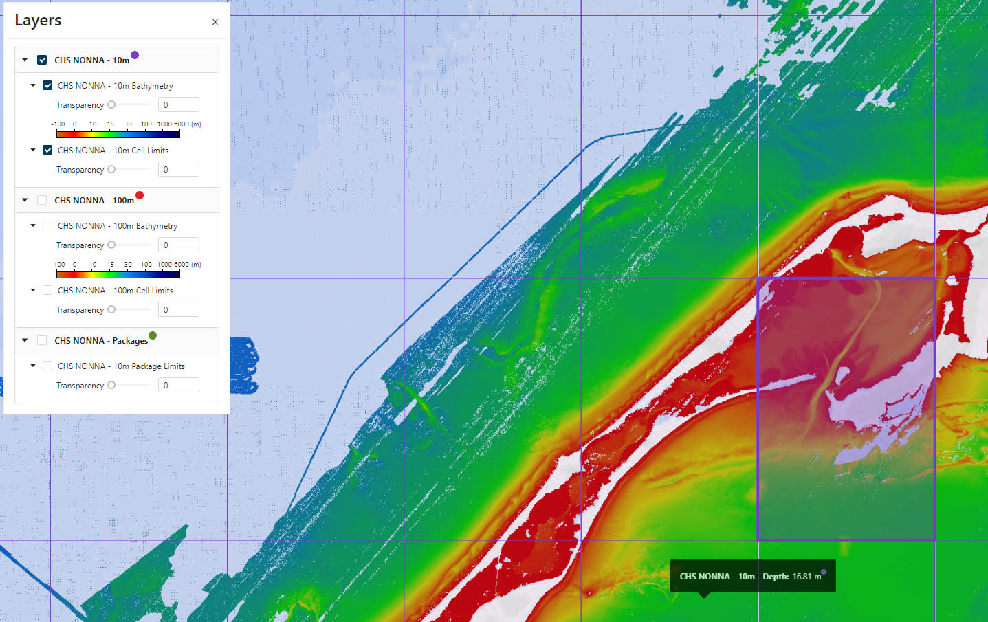 CHS NONNA 10m resolution cells selected in CARIS Cloud's catalogue of products. Data courtesy of the Canadian Hydrographic Service
To view a list of features visit the Bathy DataBASE What's New page.
Technical Specifications
| BASE Editor + BASE Manager | |
|---|---|
| Component | Recommended |
| Processor | Recent generation multi-core CPU |
| Memory | 16 GB of RAM |
| Storage | 7200 RPM disk drive or solid-state drive, minimum 1 GB available for installation |
| Display | NVidia or AMD display adapter, with an OpenGL 3.3 compatible GPU, with 2GB of memory or greater |
| Operating System | Windows 10 Professional 64-bit, or Windows 11 Professional 64-bit
|
| Bathy DataBASE Server | |
| Component | Recommended |
| Processor | Recent generation multi-core CPU |
| Memory | 16 GB of RAM |
| Storage | 7200 RPM disk drive or solid-state drive, minimum 1 GB available for installation |
| Operating System | Windows Server 2019 64-bit, or Windows Server 2022 64-bit |
| Software | If using PostgreSQL
If using Oracle
|
Videos
Downloads
Suggested Reading
| Document | Type |
|---|---|
| Centralised Data for Hamburg Port Authority | |
| Charting for the 21st Century | |
| Survey Data Management Critical to Port of Melbourne’s Operations |
