News
Survey results from UKHO-led Mulberry B World War II harbour project
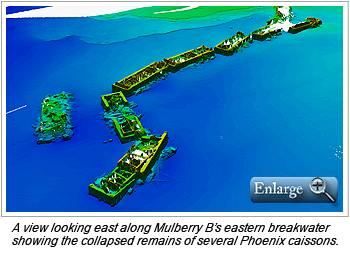
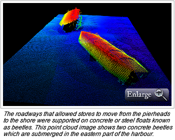
Between September 26 and October 4, 2011, the UK Hydrographic Office (UKHO) led a detailed bathymetric survey of the Mulberry ‘B’ World War II harbour off Arromanches–les–Bains on the northern coast of France. Intended primarily as a training event for the UKHO’s Seabed Data Centre staff, the survey was also designed to return detailed images of the harbour remains as a baseline from which future studies could determine the rate of decay of these important historical artifacts.
The survey was run out of the small port of Port-en-Bessin and utilized a RESON 7125s with a POS MV motion sensor, both supplied by the commercial survey company MMT NetSurvey who were a major partner in the project. Horizontal positioning used a Post-Processed Kinematic solution derived using RINEX data from external reference stations to produce a Smoothed Best Estimate of Trajectory (SBET) file via Applanix’s POSPac software. This was applied to the soundings in CARIS HIPS and SIPS. Depths were recorded as ellipsoidal heights and post-processed using a CARIS HIPS Tide file created from the SBET files, incorporating a block-shift to CD of 42.701 metres as established from GPS observations made at the tide gauge located in Port-en-Bessin.
Although high pressure dominated the first part of the survey period with light to no wind and near dead calm sea conditions work around the caissons—especially where submerged wreckage existed—was very challenging which significantly slowed the work. Also, the extremely shallow water within the harbour made gathering full seafloor coverage difficult. Finally, the wreckage is a haven for marine life and consequently is heavily potted by French fishermen. The myriad of pot markers and their attendant ropes presented a very real problem, especially as many were on short tethers and became submerged at high water. The shallowness of the water, suspected existence of large amounts of wreckage and confirmed existence of large numbers of pot markers prevented the eastern end of the harbour from being fully covered. However, using the ability of the terrestrial scanning laser to gather data from a long way off, all visible caissons were recorded by the laser.
Unfortunately in the second week the weather deteriorated and the strengthening winds, rougher seas and unsettled forecast resulted in data collection terminating two days early so as to allow the survey boat the opportunity of getting home in good time.
The survey provided a valuable learning exercise for those involved, while at the same time producing high-resolution data of the Mulberry B Harbour and associated artifacts in the region. New contacts were identified and existing charted features surveyed in detail although the vertical surfaces of the caisson wrecks often caused a lot of noise or multipath reflections necessitating careful manual editing in CARIS HIPS and SIPS. Also, the high resolution surfaces created and level of detail achievable with the multibeam and laser scanner highlighted the need for extremely accurate horizontal and vertical positioning so that overlapping data lines agreed to at least sub-decimetre level.
More details on the Mulberry harbour and survey can be found on the UKHO website.
Mulberry B survey data DVD offer
If you want to explore the remains of Mulberry B further you may wish to receive a DVD containing the survey data and other images. The DVD contains the data as .csar files viewable in CARIS’ free Easy View software (works on Windows PCs).
UKHO is making this DVD available for free, but requires a donation to be made to the UKHO's charity for 2013.
To obtain the DVD please mail a self-addressed stamped envelope (make sure it is large enough to hold a DVD) and a cheque for at least £5 made payable to UKHO Charity to:
Michelle Blagdon
UKHO
Admiralty Way
Taunton
TA1 2DN
UKHO's charity for 2013 is Freewheelers, a group that provides free out-of-hours motorcycle courier service to hospitals in the South West of England.
Join our Mailing List
Subscribe to email announcementsOur Latest Tweets
Tweets by Teledyne CARIS Follow us on TwitterConnect With Us


