News
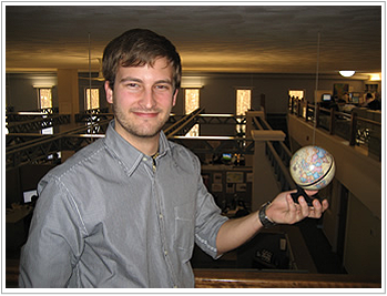
Josh Mode Appointed CARIS' New Academic Liaison
CARIS is pleased to announce the appointment of Josh Mode as their new Academic Liaison. His responsibility will be to further develop CARIS' Academic Partnering Program, which currently provides geospatial software to more than 75 academic institutions around the world.
CARIS' Academic Partnering Program was established 15 years ago with the objective to help foster the next generation of geospatial professionals by providing instructors and students with access to the latest CARIS geospatial software. Educational institutions use the software not only as part of courses in areas such as hydrography, marine sciences, geology, cartography and GIS, but also utilize the power of the software in research projects.
 It is the enhancement of career opportunities for graduates of academic institutions that Mode feels to be the greatest benefit of the Academic Partnering Program. "As a student I used CARIS software as part of my course work in marine biology and geology at the College of Charleston in South Carolina. The processing of bathymetry using CARIS software was one of the most satisfying parts of my time as a student and it was a dream for me to be employed by CARIS after graduation," he said.
Josh Mode has many new ideas that he is already incorporating into the Academic Partnering Program. "We are currently developing a package of video based tutorials, exercises and assessments. This, in the near future, will give instructors an effective way to assemble a whole credit based course," he said.
CARIS provides geospatial software to educational institutions at a discounted rate for the purpose of teaching or non-profit related research. The software products available for the Academic Partnering Program are:
- HIPS and SIPS for hydrographic data processing
- Notebook for in field feature capture
- BASE Editor for digital elevation model creation and analysis
- Engineering Analysis Module for waterway management
- S-57 Composer for electronic chart production
- LOTS for boundary delineation
- Spatial Fusion Enterprise for geospatial web discovery
For further information on CARIS' Academic Partnering Program please visit http://www.caris.com/academic/ or contact [email protected]
Join our Mailing List
Subscribe to email announcementsOur Latest Tweets
Tweets by Teledyne CARIS Follow us on TwitterConnect With Us

