News
CARIS and the S-102 bathymetric surface product specification
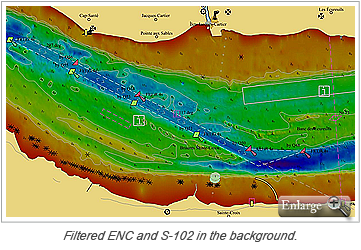
 The new S-102 standard for gridded bathymetric surfaces is currently in development under the auspices of the IHO TSMAD committee. This effort is being lead by the Canadian Hydrographic Service (CHS) and the US Naval Oceanographic Office (NAVO). The CHS completed an experiment in the production of 86 high-definition bathymetric charts using the CARIS Bathy DataBASE software.
The primary objective of S-102 is to provide a high resolution bathymetric model of the seafloor that can be integrated into an ECDIS/ECS and overlaid with the electronic chart data; thus providing more detail of the bathymetry than is available on a typical chart. These same bathymetric models could also be used in the coastal management, hydrodynamic modeling, and geology sectors. The S-102 standard includes the option to define a tiling scheme that would allow a data producer to efficiently organize their preferred production, delivery and updating system.
Production within the CARIS Bathy DataBASE suite involves preparing CSAR grids, combining them together over the area of interest and then extracting the individual tiles into separate grids along the defined boundaries of the tiling scheme. The tiled CSAR grids are then exported to the end users preferred carrier format of the product. At this time the options include the BAG format and 32bit floating point GeoTIFF.
The CARIS web mapping solution, Spatial Fusion Enterprise (SFE), supports the OGC services needed to web enable these bathymetry gridded products. The WMS/WMTS services can enable the data for display and overlay, while the WCS service provides the download capability.
For the complete details on this effort see the May 2012 issue of Hydro International.
Join our Mailing List
Subscribe to email announcementsOur Latest Tweets
Tweets by Teledyne CARIS Follow us on TwitterConnect With Us

