News
Mapping and Modelling the SS Polwell
Originally constructed in the North East of England in 1888, the SS Polwell was in use by German forces at the start of World War I. However, early in the war the vessel was captured off Gibraltar by the British Admiralty and requisitioned into service as a defensively armed merchant ship.
On June 5, 1918, the SS Polwell was on route to France with a cargo of coal. As it left the Irish coast, a warning shot by a German submarine was fired across its bow, encouraging the crew of thirty to abandon ship by lifeboat. The U-96 then fired a single torpedo at the Polwell, hitting it amidships and sinking it. All crew landed safely an hour later on shore. However the Polwell sank immediately, its final resting place approximately six miles east of the North Dublin coast.
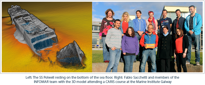
After resting on the seabed for almost a century details of this historic shipwreck have been revealed using the latest multibeam sonar technology and CARIS HIPS and SIPS™ software. Through an expedition to investigate historic wrecks, the Marine Institute Galway, through the INFOMAR program and in conjunction with Ulster University, collected a stunningly detailed point cloud survey of the SS Polwell's wreck. The dataset revealed that the ship measures 92 metres in length and although broken into three sections, it is remarkably intact considering its age.
The captivating image and dataset of the SS Polwell was submitted to CARIS on behalf of the Marine Institute Galway by Hydrographic Team Leader, Fabio Sacchetti, whose image was voted the overall winner of the annual CARIS Calendar Contest. The prize for winning was a 3D printed scale model of the SS Polwell wreck dataset.
Join our Mailing List
Subscribe to email announcementsOur Latest Tweets
Tweets by Teledyne CARIS Follow us on TwitterConnect With Us
