News
BSH commences production of Ice Coverage Marine Information Overlays
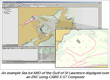
 The German Ice Service, a division of Bundesamt für Seeschifffahrt und Hydrographie (BSH), the Federal Maritime and Hydrographic Agency, recently announced they will be producing S-57 Ice Coverage Charts of the Baltic for the 2012/2013 northern hemisphere winter season using CARIS S-57 Composer. They are hoping that this will help drive other ice agencies worldwide to start creating similar products. The project will take existing ice information and create S-57 products as Ice Coverage Marine Information Overlays (MIO). These products are suitable for display on ECDIS systems as a supplemental overlay to the standard ENC or RNC.
Ice agencies collect ice data using satellites, radar, weather reports, visual reconnaissance and ship reports. The data is then analyzed to prepare products in text and chart formats. Information on ice concentration, stage of development (ice type) and floe size are available on a daily basis, which is made available for download as an image or sent directly to ships as a fax. These products can be difficult to interpret and are essentially still a paper product at the low resolution of a fax.
The BSH Ice Coverage MIO will be produced following specifications and examples developed in a pilot project for the Canadian Ice Service (CIS) by CARIS during the 2008/2009 ice season. CIS contacted CARIS to help them develop the traditional raster ice products into a digital vector product. During the pilot project CARIS developed a Sea Ice MIO product specification with ice coverage specific features and attributes, along with a dynamic S-52 portrayal specification. CARIS then trained the CIS on production of the Sea Ice MIO using CARIS S-57 Composer. CIS undertook daily Sea Ice MIO production, with trials on-board Canadian Coast Guard vessels during the winter ice season.
MIO consist of chart and navigation-related information that supplement the minimum information required by ECDIS. This can include information like ice coverage, tide/water level, current flow, meteorological, oceanographic, and marine habitats/protected areas. The Harmonization Group on Marine Information Overlays (HGMIO) was established by the IHO and IEC to recommend additional data and display specifications that can be incorporated into future editions of IHO and IEC standards, including the new S-100 standard. BSH is currently drafting an IHO S-100 compliant ice product specification.
CARIS has been an active member of HGMIO for many years and fully supports BSH efforts to drive forward the production and use of these MIO products.
Join our Mailing List
Subscribe to email announcementsOur Latest Tweets
Tweets by Teledyne CARIS Follow us on TwitterConnect With Us

