News
Bahamas and Cuba define boundary with LOTS
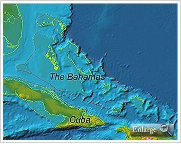
On October 3rd, 2011, a maritime boundary agreement was signed in The Bahamas between the Commonwealth of The Bahamas and the Republic of Cuba. This agreement delineates a median line in accordance with the United Nations Convention on the Law Of the Sea (UNCLOS). According to The Bahamas’ Ministry of Foreign Affairs, this maritime boundary will allow for more effective border management.
 The geodetic median line was calculated between The Bahamas’ archipelagic baseline and the Territorial Sea baseline model of Cuba. This calls for a rigorous geodetic approach compliant with UNCLOS, which is the main reason why both The Bahamas and the Republic of Cuba used the CARIS LOTS software. The Bahamas National GIS Centre acquired CARIS LOTS in 2005 while the Republic of Cuba acquired the software in 2008.
The Bahamas defined their archipelagic baseline in 2008, which opened the door to calculating the limits of the Territorial Sea (12 miles), Contiguous Zone (24 miles) and Exclusive Economic Zone (200 miles) as well as delineating maritime boundaries with neighbours. In order to establish its sovereign rights over its surrounding waters, The Bahamas will have to negotiate similar maritime boundaries with the United States, the Turks and Caicos Islands (U.K.) and Haïti.
Join our Mailing List
Subscribe to email announcementsOur Latest Tweets
Tweets by Teledyne CARIS Follow us on TwitterConnect With Us

